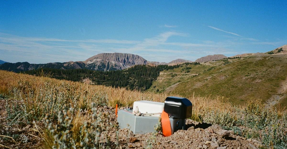
Lauren Steele: “Bushwhacking through a stand of stunted aspens above 10,000 feet in Utah’s Tushar mountain range, the mountain guide Trevor Katz held his Garmin to the sky and pointed it south. ‘We should just look for an opening,’ he said, glancing over at his colleague, Bailey Pugh, from under a ball cap he’d cut into a visor …
“Wading through walls of branches, he and Pugh circled, eyes trained on the ground. Then, there it was. Stuck in the dirt, the hexagonal silver node looked like a device an alien could have planted. Its small antenna and carrying strap sat above the earth. A sharp spike below anchored it into the slope. It would be a strange thing to stumble upon this so high in the mountains, surrounded only by what can survive at such an elevation.
“This is just one of 200 nodes planted across the range in a tidy grid, each tracked with a GPS waypoint. Earlier, they had placed the nodes in the ground; now it was time to extract them. Pugh hoisted this one out of the ground and into her pack. Then it was back to bushwhacking …
“At the beginning of the summer, Katz and Pugh had received an email from the owner of a guiding company they’d worked for in the past: A client needed mountain-savvy day workers for a new project—any interest? The biggest hint they got about the purpose of the project was the field crew’s meeting place, the Deer Trail Mine, at the mountains’ eastern base. Each team was given a set of GPS waypoints and told to take a 20-pound node, about as big as a football, to each location, plant it in the ground, and mark its location. ‘It was really mysterious,’ Levi Warr, another crew member, told me. But the pay was good—$500 a day, plus a per diem, as much as they’d usually earn for a few days of guiding—and the instructions were clear enough, so out they went.
“Only as the summer went on did the crew come to understand, from chatting with the project geologists and fieldwork managers, what exactly they were doing: helping locate some of the nation’s most in-demand minable resources across a patchwork of public and private lands. Arranged in grids that connect to low-Earth-orbit satellites, the nodes are capable of collecting and sharing data used to create high-resolution maps of anomalies, miles underground, that might be gold, copper, nickel, lithium, or other minerals.
“The nodes used in the project were first released three years ago by the Australian company Fleet Space Technologies, and although they’ve been adopted by mining giants internationally, how widely they’re being used in the United States is unclear. Compared with older and more invasive survey methods, this technology can be deployed with minimal impact. According to Fleet Space, it can be particularly useful for surveying areas where permits are required—for the Fishlake National Forest, for example, and the Bureau of Land Management territory enveloping the Tushar Mountains. If this quiet method of mineral exploration is successful, it will have threaded a loophole in the law governing public lands, helping open them for mining that much more quickly—and controversially. All it will take is a few hundred nodes, a clear view of the sky to connect to satellites, and a small team of people who know how to traverse rough terrain.”

1 Comment
Lauren Steele: “Bushwhacking through a stand of stunted aspens above 10,000 feet in Utah’s Tushar mountain range, the mountain guide Trevor Katz held his Garmin to the sky and pointed it south. ‘We should just look for an opening,’ he said, glancing over at his colleague, Bailey Pugh, from under a ball cap he’d cut into a visor …
“Wading through walls of branches, he and Pugh circled, eyes trained on the ground. Then, there it was. Stuck in the dirt, the hexagonal silver node looked like a device an alien could have planted. Its small antenna and carrying strap sat above the earth. A sharp spike below anchored it into the slope. It would be a strange thing to stumble upon this so high in the mountains, surrounded only by what can survive at such an elevation.
“This is just one of 200 nodes planted across the range in a tidy grid, each tracked with a GPS waypoint. Earlier, they had placed the nodes in the ground; now it was time to extract them. Pugh hoisted this one out of the ground and into her pack. Then it was back to bushwhacking …
“At the beginning of the summer, Katz and Pugh had received an email from the owner of a guiding company they’d worked for in the past: A client needed mountain-savvy day workers for a new project—any interest? The biggest hint they got about the purpose of the project was the field crew’s meeting place, the Deer Trail Mine, at the mountains’ eastern base. Each team was given a set of GPS waypoints and told to take a 20-pound node, about as big as a football, to each location, plant it in the ground, and mark its location. ‘It was really mysterious,’ Levi Warr, another crew member, told me. But the pay was good—$500 a day, plus a per diem, as much as they’d usually earn for a few days of guiding—and the instructions were clear enough, so out they went.
“Only as the summer went on did the crew come to understand, from chatting with the project geologists and fieldwork managers, what exactly they were doing: helping locate some of the nation’s most in-demand minable resources across a patchwork of public and private lands. Arranged in grids that connect to low-Earth-orbit satellites, the nodes are capable of collecting and sharing data used to create high-resolution maps of anomalies, miles underground, that might be gold, copper, nickel, lithium, or other minerals.
“The nodes used in the project were first released three years ago by the Australian company Fleet Space Technologies, and although they’ve been adopted by mining giants internationally, how widely they’re being used in the United States is unclear. Compared with older and more invasive survey methods, this technology can be deployed with minimal impact. According to Fleet Space, it can be particularly useful for surveying areas where permits are required—for the Fishlake National Forest, for example, and the Bureau of Land Management territory enveloping the Tushar Mountains. If this quiet method of mineral exploration is successful, it will have threaded a loophole in the law governing public lands, helping open them for mining that much more quickly—and controversially. All it will take is a few hundred nodes, a clear view of the sky to connect to satellites, and a small team of people who know how to traverse rough terrain.”
Read more: [https://theatln.tc/FFV1Stum](https://theatln.tc/FFV1Stum)